Mapping Poverty
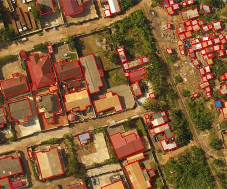
There is a common saying in international development that you can fix the world’s problems such as poverty and hunger only if you know where they are. Gathering data on the ground can be dangerous, slow, and expensive but satellite imagery and advances in machine learning are revealing that it is possible to map poverty from space. At night it is possible to differentiate socioeconomic regions of a city by mapping the glow of electric lights and infrastructure. During the day it is possible to identify differences and poverty indicators such as dirt/mud roads and tiny clusters of dwellings and informal settlements, and things such as distance to nearest source of freshwater or nearest marketplace. Machine learning algorithms can be trained to identify specific features and indicators making the process even less time intensive. It is noted however that ground based surveys are still needed and a critical piece of the puzzle. Validation is critical and the combination of survey data and data extracted from satellite images is making large leaps in the potential to identify and map regions of interest. These analytics then allow for more focused humanitarian efforts around service delivery and distribution of resources that can uplift communities out of poverty. Informal settlements can be mapped and identified using building footprint extraction models such as the open source Ramp model.1